CHAPTER 28
"scenes from the Rio Cuervo in New Mexico on November 11th 2006"
TO TABLE OF CONTENTS
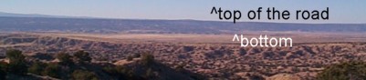
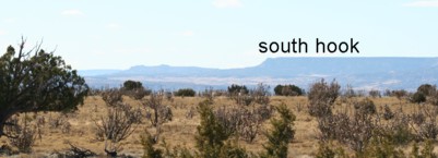
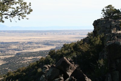
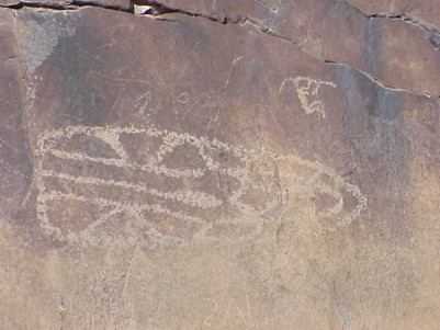
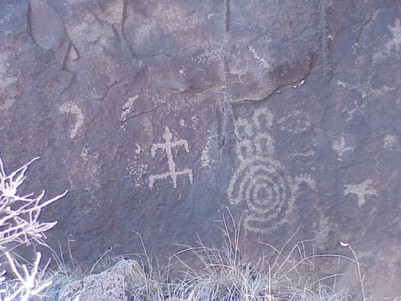
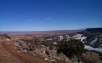
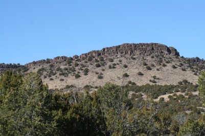
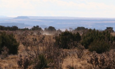
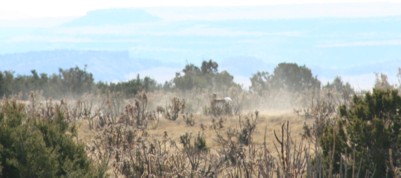
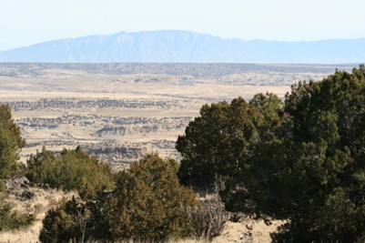
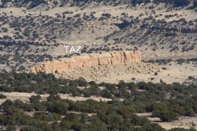
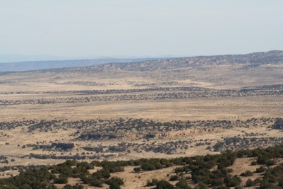
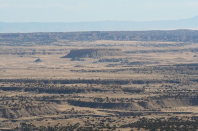
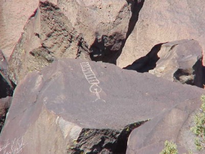
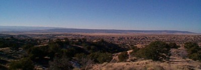
The entire ranch is a geological erosion of an ancient sea bed. As a recent part of the out crop is a large mesa about six miles long and just a mile wide with a flat top. There are three main water tanks made by the ranchers in the middle, north and south ends. The middle tank is shallow and incomplete without water most of the time. The south end of the mesa was our destination this time. Tom the photographer was to be my side kick on the trip. I had many misgivings about this trip. My first was and is always the road to the top.There are only about three watershed or depression points along the mesa. The center water shed is the greatest and pulls from about a 3 mile area to lead down the mesa to the center creating the big water fall and all those wonderful canyons near TAZ. The second largest water shed is near the center north and is the pass that the aborigine's uses to mount the mesa. Next to this water shed crossing in many time is the narrow 9 foot road that winds its way to the top of the mesa not without hazards of many kinds. This make shift road is about 3 miles from the base of the mesa to the top. At times the angle of assent is about 35 degrees. This make the loose stones an unsafe surface to loose traction with. This is also the limit my Hummer will do fully loaded and you don't make this trip without a full load. What's in our load? On the roof of the Hummer with the 5 roof mounted lamps is the spare tire, a hi lift jack with two shovels and a solar light. Inside would be a 3 day emergency bag food water and meds. Chains, more shovel and pick, day packs, gun belts, flares and lots of radios and satellite phone. The list of items would take 10 pages and each item is a result of a need either experienced or thought of. The object of this dangerous climb was to see if the large herd of elk and antelope was at the top near the south tank. Because it is winter we left a little later so that any south side snow would have melted and we would not be facing a slippery road. The last time I took this road it was ice and snow. I was badly frightened on the way up but terrified to find that behind me the road was melting and becoming unpassable without sliding off into the abyss below. I told my side kick we must turn around at the top and leave before the road became melted completely. And that's just what I did. The time before that Mike and I parked at the bottom and climbed about two miles of the road only to find at the top that Mike's boots had breached and water was inside freezing his feet. Once again back to the bottom we went. These were my last two October November trips. So this one was planned when there had been very little snow just a dusting. And we would approach the road at midday and make the decision based on conditions. Many of the roads on the ranch have been destroyed and rendered unpassable because of the dramatic rains in the last 18 months. We found that the normal road to the base of prieta had some very dicey and going was slow. There is a man made dam at the base of the mesa and the road. It had broken and the road had been washed through. There are a couple of level areas as you go the first third of the road, then a pipe gate that is locked. To your south as you wind up the road are some meadows but for the most part just a sheer drop off sometimes a couple of hundred feet. You get to imagine a 7,000 pound Hummer tumbling through the air with you in it. The worse part of the drive is that last third which feels like a 45 degree on rolling rocks with about a foot between your driver side and the abyss below. The views are dramatic but the price is high and you don't get to stop the car and get out on that last third up. The Natives have used the water shed as their way up for thousands of years. As a result there are many petroglyphs on the way up. Some are obvious others very abstract. Once on top I positioned some emergency drinking water as my last stash was gone. The last hill before the top is imposing. I stopped to look back. I noticed that no vehicles had been on the top in quite a while but recent horse shod prints were there. You gotta admire those cowboys up here looking after the cows. We drove to the south end and to our amazement there was a small herd of burros. Just beyond them you could see a large heard of antelope making a hasty departure from the tank and cutting to the west. The tank was about half full. The heard stopped to examine us. At that time Tom got out of the car and took some pictures. Then the heard cut to the south and off the end of the mesa to the meadows below. The views from this mesa are dramatic in all directions. From the north you can see the great Cabezone monument. Because of the elevation about 7,000 feet you can see the Sandia's off to the east and all of the ranch canyons and mesa camp below. You can see TAZ below. Notice the lake on the ranch in the middle. To the west lay open ancient lands between Prieta and Mt. Taylor with the volcanic vents and stems frozen in their ancient eruptions of lava which makes the surface under your feet. This would be the medium for those ancient artist and historians carving the petroglyphs. To the south you can see miles of rugged Laguna Reservation areas. There on the south east you are now higher than felipe Mesa in the middle of the badlands. Time it took to drive up the road, one hour. Time down the road, 45 minutes. Time on top, two hours. We did not have time to look for those ancient villages that were at the high end of the ladders depicted in the petroglyphs as any unforeseen problem could put us at risk. If we experience just a flat tire we would be coming down the road in the dark. The trip down was uneventful but I felt like I had been doing brain surgery all day because of the attention and concentration it takes to drive this road. I have made up my mind to drive it only in the dry summer from now on. All and all this is another great day at the ranch. I am having more fun than I every expected. It is always nice to come back without having to use any of the emergency equipment I carry. I will spend the next two days checking the equipment and the Hummer for the next trip.
email us
YOU MUST PUT FORM SUB: IN THE SUBJECT LINE
copyright 1995-2006 Chuck Dawson Corrales NM

//our home//
1
2
3
4
5
6
7
8
9
x
11
12
13
14
16
16
17
18
19
20
21
22
23
24
25
26
27
28
29